

What is long-term seismic hazard?
Long-term seismic hazard represents the level of ground shaking that has a given probability of being exceeded at a specific site within a defined time interval - typically several decades (commonly 50 years).
It is a fundamental tool for:
- the seismic classification of a territory,
- the definition of the reference seismic action in the building code ,
- and the assessment of seismic risk at national or regional scales.
How is it calculated?
Long-term seismic hazard is estimated using a probabilistic approach (PSHA) that combines multiple datasets and models (Figure 1), including:
- earthquake catalogues derived from historical and instrumental data,
- catalogues of active faults and geodetic data,
- seismotectonic models of the territory,
- earthquake occurrence models as a function of magnitude,
- predictive models describing ground-motion attenuation with distance from the source.
For seismic design purposes, the shaking parameter currently adopted by building codes is ground acceleration, expressed both as Peak Ground Acceleration (PGA) and as spectral acceleration at various periods. Other parameters of interest may include peak or spectral velocity or displacement, macroseismic intensity, and others depending on the application.
How are the results represented?
The results of long-term seismic hazard assessment are typically represented as:
- hazard maps, showing the level of ground shaking (e.g., acceleration) associated with different probabilities of exceedance within a given time period (e.g., in 50 years) over a specific area;
- hazard curves, defining the annual frequency of exceedance—or equivalently, the probability of exceedance within a given time period—of specific ground-shaking levels at a given site;
- uniform hazard spectra, defining ground-shaking values (e.g., acceleration) for various spectral periods (e.g., between 0.1 and 2 seconds) and different exceedance probabilities in a given time period (e.g., in 50 years) for a given site;
- disaggregation, identifying the combinations of magnitude and source-to-site distance that contribute most to the seismic hazard at a specific site.
The Reference Seismic Hazard Model for Italy (MPS04)
The long-term reference seismic hazard model for Italy (MPS04, Figure 2, http://esse1.mi.ingv.it/), which underpins the current national seismic classification and building code, was developed between 2004 and 2006 using the most up-to-date knowledge and data available at that time regarding earthquake catalogues, seismic source models, and ground-motion attenuation relationships (for further details, see http://zonesismiche.mi.ingv.it).
Towards the new National Seismic Hazard Model
In early 2025, the CPS (Centro di Pericolosità Sismica, Seismic Hazard Center) launched the ISHM Project (Italian Seismic Hazard Model) to develop a new national long-term seismic hazard model aimed at supporting future seismic design codes.
ISHM will follow the two previous seismic hazard models developed for Italy: MPS04, which remains the current reference model for defining seismic actions in the building code, and the more recent MPS19 model, developed by the CPS between 2015 and 2019 https://zenodo.org/records/7032251#.YxHIxuxByb8). The ISHM will integrate the most up-to-date data, models, and methodologies available today, fully aligned with international best scientific practices.
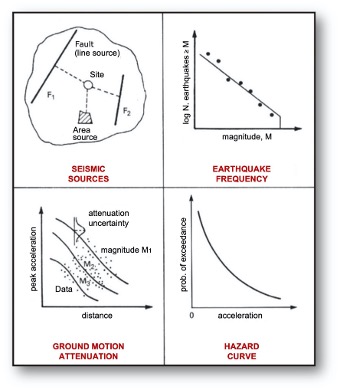 Figure 1- Illustration of the basic elements for PSHA.
Figure 2 - Seismic hazard map in terms of PGA values (expressed as a fraction of the acceleration of gravity, g) with a 10% probability of exceedance in 50 years (MPS04 model, http://zonesismiche.mi.ingv.it).